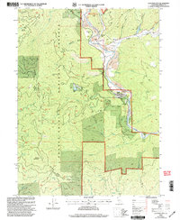
1998 Map of Junction City
USGS Topo · Published 2003About this map
Junction City sits at the confluence of the Trinity River and Canyon Creek, serving as a focal point for the resource-driven landscape of Trinity County in the late 1990s. The map reveals a legacy of industrial activity, with extensive tailings deposits flanking the riverbanks and multiple open pit mines located near Sheridan. These features highlight the area's gold-mining heritage, which shaped the settlement patterns of the river canyon. Beyond the water, the terrain rises sharply into the Shasta-Trinity National Forests, where the Hayfork Divide separates the river basin from the high ridgelines. Small residential and agricultural pockets like Benjamin Flat, Hocker Flat, and Chapman Ranch are tucked into the narrow alluvial plains, while landmarks such as Barker Mountain and Rattlesnake Gap dominate the interior wilderness.
Find a feature on this map
43 named features on this map. Tap any name to fly to it.
Don’t see what you’re looking for? This feature index may not catch every label — zoom into the map to look around manually.
Map Details
Editions of this 1998 Junction City Map
This is the sole edition of this map. No revisions or reprints were ever made.
Other maps of this area

1890 · Red Bluff
USGS Topo · 1:250,000

1894 · Red Bluff
USGS Topo · 1:250,000

1909 · Big Bar
USGS Topo · 1:96,000

1913 · Weaverville
USGS Topo · 1:125,000

1915 · Big Bar and Vicinity
USGS Topo · 1:250,000

1950 · Minersville
USGS Topo · 1:62,500

1950 · Weaverville
USGS Topo · 1:62,500

1951 · Hayfork
USGS Topo · 1:62,500

1951 · Helena
USGS Topo · 1:62,500

1952 · Weaverville
USGS Topo · 1:62,500