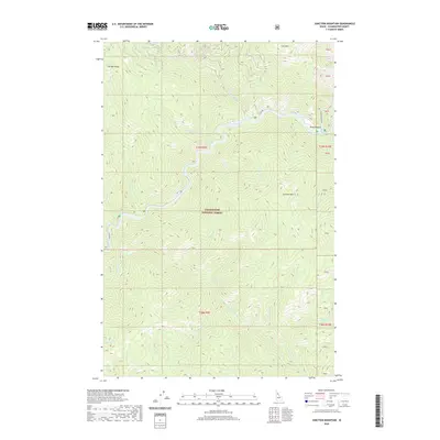
2020 Map of Junction Mountain
USGS Topo · Published 2020About this map
The North Fork Clearwater River carves a deep path through the Clearwater National Forest in this interior section of the Idaho panhandle. Dominating the central topography, Junction Mountain rises above the confluence of Junction Creek and the main river channel, while Pot Mountain Ridge defines the northwestern horizon. The landscape is a complex network of drainages, including Fourth of July Creek, Adams Creek, and Ice Creek, which feed into the primary river system. Transportation through this remote terrain is limited to a few arterial routes such as County Road 250 and Black Canyon Road, which follow the natural contours of the river valleys. This map illustrates the intersection of high mountain peaks like Flat Mountain with the steep river gorges that have historically dictated access and resource management within this protected forest region.
Find a feature on this map
29 named features on this map. Tap any name to fly to it.
Don’t see what you’re looking for? This feature index may not catch every label — zoom into the map to look around manually.
Map Details
Editions of this 2020 Junction Mountain Map
This is the sole edition of this map. No revisions or reprints were ever made.
Other maps of this area

1911 · Lolo
USGS Topo · 1:250,000

1913 · Lolo
USGS Topo · 1:250,000

1956 · Hamilton
USGS Topo · 1:250,000

1959 · Hamilton
USGS Topo · 1:250,000

1960 · Hamilton
USGS Topo · 1:250,000
1963 · The Nub
USGS Topo · 1:24,000
1963 · Elizabeth Lake
USGS Topo · 1:24,000

1964 · Hamilton
USGS Topo · 1:250,000

1965 · Junction Mtn
USGS Topo · 1:24,000
1965 · Moose Mtn
USGS Topo · 1:24,000