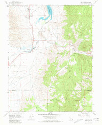
1966 Map of Junction
USGS Topo · Published 1981About this map
Junction and Kingston serve as the primary hubs in this mid-1960s survey of the Circle Valley region. The landscape is defined by the critical management of water for agriculture, illustrated by the West Canal, Circleville Canal, and the expansive Piute Reservoir with its recorded spillway elevation of 5971 feet. Local civic life is anchored by the Piute High Sch and the Junction Municipal Airport, while the proximity of the Dixie National Forest and Table Mountain to the southeast marks the transition from valley floor to high-country terrain. Small-scale resource extraction is evident through various prospects and a borrow pit near the Sevier River. The map meticulously records the infrastructure of the era, from the radio tower west of town to the various gaging stations that monitored the vital flow of Rocky Ford Creek and the Sevier River.
Find a feature on this map
31 named features on this map. Tap any name to fly to it.
Don’t see what you’re looking for? This feature index may not catch every label — zoom into the map to look around manually.
Map Details
Editions of this 1966 Junction Map
3 editions found
Other maps of this area

1885 · Beaver
USGS Topo · 1:250,000

1937 · Delano Peak
USGS Topo · 1:48,000

1943 · Delano Peak
USGS Topo · 1:62,500

1945 · Marysvale
USGS Topo · 1:62,500

1947 · Marysvale
USGS Topo · 1:62,500

1953 · Richfield
USGS Topo · 1:250,000

1958 · Richfield
USGS Topo · 1:250,000

1966 · Bull Rush Peak
USGS Topo · 1:24,000

1966 · Circleville
USGS Topo · 1:24,000
1966 · Junction
USGS Topo · 1:24,000