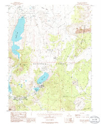
1986 Map of June Lake
USGS Topo · Published 1986About this map
June Lake and its neighboring waters sit at the center of this volcanic alpine landscape during the mid-1980s. The settlement at June Lake is surrounded by dramatic geological formations, including the volcanic Mono Craters to the east and the massive Obsidian Dome to the southeast. Water management and recreation are primary themes, evidenced by the series of interconnected lakes—Gull Lake, Silver Lake, and Grant Lake—linked by Rush Creek and supported by infrastructure like the Pumping Station and Sewage Disposal Ponds in Pumice Valley.
Find a feature on this map
28 named features on this map. Tap any name to fly to it.
Don’t see what you’re looking for? This feature index may not catch every label — zoom into the map to look around manually.
Map Details
Editions of this 1986 June Lake Map
This is the sole edition of this map. No revisions or reprints were ever made.
Other maps of this area

1901 · Mt. Lyell
USGS Topo · 1:125,000

1914 · Mt. Morrison
USGS Topo · 1:125,000

1947 · Mariposa
USGS Topo · 1:250,000

1948 · Mariposa
USGS Topo · 1:250,000

1953 · Mt. Morrison
USGS Topo · 1:62,500

1953 · Mono Craters
USGS Topo · 1:62,500

1953 · Devils Postpile
USGS Topo · 1:62,500

1957 · Mariposa
USGS Topo · 1:250,000

1962 · Cowtrack Mtn
USGS Topo · 1:62,500

1963 · Mariposa
USGS Topo · 1:250,000