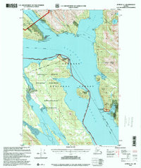
1996 Map of Juneau A-1
USGS Topo · Published 2000About this map
Industrial ruins and remote wilderness dominate this landscape south of the city. The Alaska Treasure Mine and associated Mill Ruins sit on the eastern shore of Douglas Island, overlooking the waters of the Gastineau Channel. This corridor served as a vital maritime artery, noted here by the presence of a Subcable Repeater and several gaging and weather stations. To the south, the map captures the transition into protected lands, including the vast Kootznoowoo Wilderness on Admiralty Island. The eastern shore of Stephens Passage is punctuated by Taku Harbor, where a Boat Dock and the Taku Harbor State Marine Park mark an essential refuge for vessels navigating the Alaska Marine Highway. A short Tramway near Oliver Inlet suggests the localized transport methods once used to portage goods across the narrowest points of the Glass Peninsula.
Find a feature on this map
66 named features on this map. Tap any name to fly to it.
Don’t see what you’re looking for? This feature index may not catch every label — zoom into the map to look around manually.
Map Details
Editions of this 1996 Juneau A-1 Map
This is the sole edition of this map. No revisions or reprints were ever made.
Other maps of this area

1947 · Juneau B-2
USGS Topo · 1:63,360

1948 · Sitka D-1
USGS Topo · 1:63,360

1948 · Sitka D-2
USGS Topo · 1:63,360

1948 · Sumdum D-6
USGS Topo · 1:63,360

1948 · Juneau B-1
USGS Topo · 1:63,360

1949 · Juneau B-2
USGS Topo · 1:62,500

1951 · Juneau
USGS Topo · 1:250,000

1951 · Taku River B-6
USGS Topo · 1:63,360

1951 · Taku River A-6
USGS Topo · 1:63,360

1951 · Juneau A-2
USGS Topo · 1:63,360