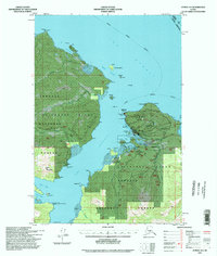
1994 Map of Juneau A-5
USGS Topo · Published 1998About this map
Hoonah serves as the primary coastal settlement on this portion of Chichagof Island, situated where Port Frederick meets the Icy Strait. The landscape is defined by the maritime infrastructure of the late twentieth century, including the Lighthouse Reserve, Cannery Point, and multiple boat docks and piers serving the local economy. Beyond the town center, the map documents industrial and communal outposts such as the Whitestone Logging Camp and the Mt Bether Bible Center, alongside technical landmarks like the White Alice Comm Site and Communication Towers. The interior remains largely dominated by the Tongass National Forest, featuring topographical landmarks like Neka Mountain and drainage systems including Game Creek and Gartina Creek. Transportation is primarily waterborne, though the Spasski Trail and Hoonah Airport provide critical links to the surrounding wilderness and neighboring boroughs.
Find a feature on this map
73 named features on this map. Tap any name to fly to it.
Don’t see what you’re looking for? This feature index may not catch every label — zoom into the map to look around manually.
Map Details
Editions of this 1994 Juneau A-5 Map
This is the sole edition of this map. No revisions or reprints were ever made.
Other maps of this area

1948 · Juneau B-4
USGS Topo · 1:63,360

1948 · Juneau B-6
USGS Topo · 1:63,360

1948 · Juneau A-4
USGS Topo · 1:63,360

1948 · Juneau B-5
USGS Topo · 1:63,360

1948 · Sitka D-5
USGS Topo · 1:63,360

1948 · Sitka D-4
USGS Topo · 1:63,360

1948 · Sitka D-6
USGS Topo · 1:63,360

1949 · Juneau B-4
USGS Topo · 1:63,360

1950 · Juneau B-5
USGS Topo · 1:63,360

1951 · Juneau
USGS Topo · 1:250,000
Featured Places
- Hoonah, AK
- Whitestone Logging Camp (Abandoned), AK
- Whitestone Logging Camp, AK
- Game Creek, AK
- Unorganized Borough, AK