
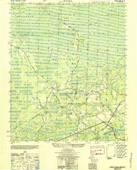
1942 Map of Juniper Creek
USGS Topo · Published 1962About this map
Green Swamp and Waccamaw Swamp dominate this 1942 survey of the North Carolina coastal plain, showing a landscape defined by expansive wetlands and low-lying ridges. The terrain is a network of named "bays" and "fields" that indicate early 20th-century land use amidst the heavy swamp forest, including Millpond Bay and Ward Field. Small clearings and settlements like Clewis Corner and Myrtle Head are connected by unimproved roads that trace the higher ground of Schoolhouse Ridge and Cox Ridge.
Find a feature on this map
32 named features on this map. Tap any name to fly to it.
Don’t see what you’re looking for? This feature index may not catch every label — zoom into the map to look around manually.
Map Details
Editions of this 1942 Juniper Creek Map
This is the sole edition of this map. No revisions or reprints were ever made.
Other maps of this area

1943 · Freeland
USGS Topo · 1:24,000

1943 · Honey Island
USGS Topo · 1:24,000

1943 · Exum
USGS Topo · 1:24,000

1943 · Supply
USGS Topo · 1:24,000

1944 · Supply
USGS Topo · 1:31,680
1950 · Supply
USGS Topo · 1:25,000

1953 · Florence
USGS Topo · 1:250,000

1954 · Florence
USGS Topo · 1:250,000

1954 · Bolton
USGS Topo · 1:62,500

1955 · Whiteville
USGS Topo · 1:62,500