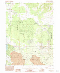
1984 Map of Juniper Flat
USGS Topo · Published 1984About this map
Juniper Flat and the surrounding Shasta Valley define the northern California landscape where agricultural water management meets volcanic geology. In the southwest corner, the impounded waters of Lake Shastina are held by the Dwinnell Dam, supporting an irrigation network that includes the Main Canal and numerous smaller channels. This infrastructure contrast sharply with the undeveloped eastern reaches of the Klamath National Forest, where unique geological features such as Pluto Cave, Lava Tubes, and the prominent Yellow Butte dominate the terrain. The presence of Pumice and several Borrow Pits indicates the local extraction of volcanic materials. Along the southern boundary, the Southern Pacific railroad passes through the settlement of Afton and follows the course of Graham Creek, illustrating the historical importance of rail transit through the timber and ranch lands of the Shasta National Forest.
Find a feature on this map
34 named features on this map. Tap any name to fly to it.
Don’t see what you’re looking for? This feature index may not catch every label — zoom into the map to look around manually.
Map Details
Editions of this 1984 Juniper Flat Map
This is the sole edition of this map. No revisions or reprints were ever made.
Other maps of this area

1886 · Shasta
USGS Topo · 1:250,000

1894 · Shasta
USGS Topo · 1:250,000

1921 · Shasta Valley Sheet No 11
USGS Topo · 1:24,000

1922 · Shasta Valley Sheet No 10
USGS Topo · 1:24,000

1922 · Shasta Valley Sheet No 10 E
USGS Topo · 1:24,000

1922 · Shasta Valley Sheet No 9
USGS Topo · 1:24,000

1934 · Macdoel
USGS Topo · 1:96,000

1935 · Dunsmuir
USGS Topo · 1:125,000

1941 · Macdoel
USGS Topo · 1:125,000

1948 · Weed
USGS Topo · 1:250,000