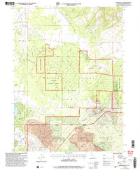
2001 Map of Juniper Flat
USGS Topo · Published 2004About this map
Shasta Valley dominates this landscape at the base of the Cascades, where the volcanic history of the region is written across the terrain in a sprawling Lava Flow and prominent Lava Tubes. The map captures the specialized development around the southern edge of the valley, featuring the Lake Shastina Golf Resort and the essential infrastructure of the Dwinnell Dam, which regulates the water that defines this arid corridor. Away from the greens and resorts, the land remains largely working forest and ranchland, organized under the Klamath National Forest and Shasta National Forest. Agricultural and aviation markers like the Grain Bins and Coonrad-Rahesh Airport near Conrad Ranch indicate a landscape where light industry and rural operations coexist. The transition from the flat basin of Juniper Flat to the rising elevations of Yellow Butte illustrates the complex topography managed by the Goosenest Ranger District.
Find a feature on this map
31 named features on this map. Tap any name to fly to it.
Don’t see what you’re looking for? This feature index may not catch every label — zoom into the map to look around manually.
Map Details
Editions of this 2001 Juniper Flat Map
This is the sole edition of this map. No revisions or reprints were ever made.
Other maps of this area

1886 · Shasta
USGS Topo · 1:250,000

1894 · Shasta
USGS Topo · 1:250,000

1921 · Shasta Valley Sheet No 11
USGS Topo · 1:24,000

1922 · Shasta Valley Sheet No 10
USGS Topo · 1:24,000

1922 · Shasta Valley Sheet No 10 E
USGS Topo · 1:24,000

1922 · Shasta Valley Sheet No 9
USGS Topo · 1:24,000

1934 · Macdoel
USGS Topo · 1:96,000

1935 · Dunsmuir
USGS Topo · 1:125,000

1941 · Macdoel
USGS Topo · 1:125,000

1948 · Weed
USGS Topo · 1:250,000