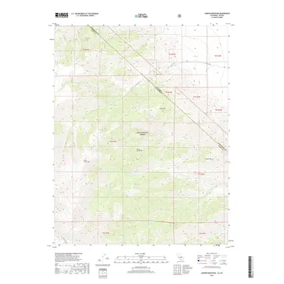
2018 Map of Juniper Mountain
USGS Topo · Published 2018About this map
The White- Inyo Range dominates this high-altitude landscape along the border of Nevada and California, providing a stark topographical study of the eastern Great Basin. Much of the terrain is managed as part of the Inyo National Forest, where steep canyons and high ridges define the drainage patterns of numerous mountain streams. Significant watercourses like Liedy Creek, Busher Cr, and the multiple branches of Perry Aiken Cr flow eastward from the high peaks toward the valley floor below. Distinctive landmarks such as Juniper Mtn and Pinyon Mtn rise above the surrounding slopes, while the relatively level expanse of Perry Aiken Flat offers a rare break in the vertical relief. This survey preserves the complex network of forest boundaries and section lines that segment this arid, mountainous region.
Find a feature on this map
22 named features on this map. Tap any name to fly to it.
Don’t see what you’re looking for? This feature index may not catch every label — zoom into the map to look around manually.
Map Details
Editions of this 2018 Juniper Mountain Map
This is the sole edition of this map. No revisions or reprints were ever made.
Other maps of this area

1917 · White Mountain
USGS Topo · 1:125,000

1947 · Mariposa
USGS Topo · 1:250,000

1948 · Mariposa
USGS Topo · 1:250,000

1957 · Mariposa
USGS Topo · 1:250,000

1962 · Benton
USGS Topo · 1:62,500

1962 · Mt. Barcroft
USGS Topo · 1:62,500

1962 · White Mtn. Peak
USGS Topo · 1:62,500

1963 · Mariposa
USGS Topo · 1:250,000

1963 · Davis Mountain
USGS Topo · 1:62,500
1987 · East of Davis Mtn.
USGS Topo · 1:24,000