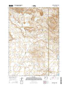
2014 Map of Juniper Point
USGS Topo · Published 2014About this map
The high desert landscape along the border of Oregon and Idaho is defined by its seasonal water management and distinct landforms. This part of Malheur County is anchored by Juniper Point and the prominent volcanic shelf of The Flatiron, where drainage follows ephemeral paths like Stove Cr and Mud Flat Cr. The area’s ranching legacy is evident in the distribution of water features, including Gartin Reservoir, Corta Reservoir, and the CCC Reservoir, the latter suggesting historical public works projects in this arid environment. Transportation through the sagebrush and rangeland is limited to long-standing corridors such as Chas-Maher Ranch Rd and Fenwick Ranch Rd, which connect isolated water sources like Twin Lakes to higher ground at Castro Ridge. Landforms like Coyote Point and Schoolhouse Gulch provide navigational landmarks in a region largely dedicated to open range and reservoir irrigation.
Find a feature on this map
42 named features on this map. Tap any name to fly to it.
Don’t see what you’re looking for? This feature index may not catch every label — zoom into the map to look around manually.
Map Details
Editions of this 2014 Juniper Point Map
This is the sole edition of this map. No revisions or reprints were ever made.
Other maps of this area

1955 · Jordan Valley
USGS Topo · 1:250,000

1957 · Jordan Valley
USGS Topo · 1:250,000

1958 · Jordan Valley
USGS Topo · 1:250,000

1965 · Flint Creek
USGS Topo · 1:62,500
1969 · Juniper Ridge
USGS Topo · 1:24,000

1973 · Fairylawn
USGS Topo · 1:24,000

1973 · Cliffs
USGS Topo · 1:24,000

1980 · Brewster Reservoir
USGS Topo · 1:24,000

1980 · Three Forks
USGS Topo · 1:24,000

1980 · Juniper Point
USGS Topo · 1:24,000