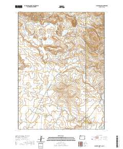
2020 Map of Juniper Point
USGS Topo · Published 2020About this map
The High Desert along the border of Oregon and Idaho is defined by a series of high-altitude water management features and prominent terrain markers. Juniper Point rises as a central landmark amidst a network of catchments including the CCC Reservoir, Gartin Reservoir, and Sheep Creek Reservoir. This arid landscape is crossed by ranch roads named for early settlers and topographical features, such as Chas-Maher Ranch Rd and Gulch Place Rd. The area’s geography is shaped by drainages like Soldier Cr and Mud Flat Cr, which eventually give way to distinct landforms like The Flatiron and Castro Ridge. The presence of the Arritola Ditch and several named reservoirs highlights the persistent efforts to manage water for livestock and land use in this remote corner of Malheur County.
Find a feature on this map
41 named features on this map. Tap any name to fly to it.
Don’t see what you’re looking for? This feature index may not catch every label — zoom into the map to look around manually.
Map Details
Editions of this 2020 Juniper Point Map
This is the sole edition of this map. No revisions or reprints were ever made.
Other maps of this area

1955 · Jordan Valley
USGS Topo · 1:250,000

1957 · Jordan Valley
USGS Topo · 1:250,000

1958 · Jordan Valley
USGS Topo · 1:250,000

1965 · Flint Creek
USGS Topo · 1:62,500
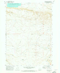
1969 · Juniper Ridge
USGS Topo · 1:24,000

1973 · Fairylawn
USGS Topo · 1:24,000

1973 · Cliffs
USGS Topo · 1:24,000

1980 · Brewster Reservoir
USGS Topo · 1:24,000

1980 · Three Forks
USGS Topo · 1:24,000

1980 · Juniper Point
USGS Topo · 1:24,000