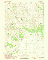
1989 Map of Juniper Ridge
USGS Topo · Published 1989About this map
Juniper Ridge rises over a landscape defined by ranching and essential water sources in the high desert of Lassen County. In the late 1980s, the Harry Marr Ranch and Brin Marr Ranch serve as primary anchors of human activity in this corner of the Madeline Plains. The terrain is punctuated by numerous named water features critical for high-country survival, such as Etchecopar Spring, Dodge Spring, and Dill Field Spring, while the broader drainage is influenced by the course of Dry Creek.
Find a feature on this map
22 named features on this map. Tap any name to fly to it.
Don’t see what you’re looking for? This feature index may not catch every label — zoom into the map to look around manually.
Map Details
Editions of this 1989 Juniper Ridge Map
This is the sole edition of this map. No revisions or reprints were ever made.
Other maps of this area

1886 · Alturas
USGS Topo · 1:250,000

1886 · Honey Lake
USGS Topo · 1:250,000

1891 · Honey Lake
USGS Topo · 1:250,000

1892 · Alturas
USGS Topo · 1:250,000

1893 · Honey Lake
USGS Topo · 1:250,000

1954 · Observation Peak
USGS Topo · 1:62,500

1954 · Ravendale
USGS Topo · 1:62,500

1954 · Alturas
USGS Topo · 1:250,000

1955 · Westwood
USGS Topo · 1:250,000

1958 · Alturas
USGS Topo · 1:250,000