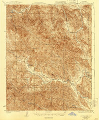
1919 Map of Junipero Serra
USGS Topo · Published 1940About this map
Los Padres National Forest dominates this interior portion of the Santa Lucia Range as surveyed in 1917. The topography is defined by significant elevations like Junipero Serra Pk and Cone Peak, with a network of drainages including the Arroyo Seco and the upper reaches of the San Antonio River. The settlement pattern consists almost entirely of isolated cattle ranches and administrative outposts, reflecting the era's deep-country agricultural and forest management practices.
Find a feature on this map
40 named features on this map. Tap any name to fly to it.
Don’t see what you’re looking for? This feature index may not catch every label — zoom into the map to look around manually.
Map Details
Editions of this 1919 Junipero Serra Map
5 editions found
Other maps of this area

1912 · Metz
USGS Topo · 1:31,680

1915 · Soledad
USGS Topo · 1:62,500

1919 · King City
USGS Topo · 1:62,500

1919 · Junipero Serra
USGS Topo · 1:62,500

1919 · Bryson
USGS Topo · 1:62,500

1920 · Jamesburg
USGS Topo · 1:48,000

1921 · Cape San Martin
USGS Topo · 1:62,500

1921 · Jamesburg
USGS Topo · 1:62,500

1921 · Metz
USGS Topo · 1:62,500

1921 · Lucia
USGS Topo · 1:62,500