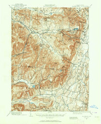
1892 Map of Kaaterskill
USGS Topo · Published 1964About this map
The northern Catskill mountain landscape is defined by its deep cloves and high peaks in this 1892 survey, a period when the region was becoming a premier destination for summer tourism. The famous Mountain House overlooks the steep drop into the valley, while the intricate rail network of the Ulster and Delaware R.R. and the Elevating R.R. navigate the challenging grades around Kaaterskill Junction.
Find a feature on this map
87 named features on this map. Tap any name to fly to it.
Don’t see what you’re looking for? This feature index may not catch every label — zoom into the map to look around manually.
Map Details
Editions of this 1892 Kaaterskill Map
3 editions found
Other maps of this area

1892 · Kaaterskill
USGS Topo · 1:62,500

1893 · Kaaterskill
USGS Topo · 1:62,500

1893 · Coxsackie
USGS Topo · 1:62,500

1893 · Durham
USGS Topo · 1:62,500

1894 · Coxsackie
USGS Topo · 1:62,500

1894 · Kaaterskill
USGS Topo · 1:62,500

1894 · Durham
USGS Topo · 1:62,500

1895 · Catskill
USGS Topo · 1:62,500

1898 · Rhinebeck
USGS Topo · 1:62,500

1899 · Kaaterskill
USGS Topo · 1:62,500