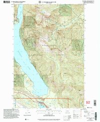
2003 Map of Kachess Lake
USGS Topo · Published 2006About this map
Kachess Lake dominates the central landscape of this Kittitas County survey, showing the complex water management and recreation infrastructure of the early 21st century. The map details the Kachess Dam and Kachess Gaging Station at the southern end, where the lake feeds into the Yakima River valley. To the south, the settlement of Easton is shown adjacent to Lake Easton State Park and the Easton State Airport, illustrating a region heavily utilized for both public transport and state-managed outdoor recreation. The surrounding terrain is defined by the high peaks of the Wenatchee National Forest, including Thorp Mountain and Thomas Mountain. Geologic interest is found in the northern basins and local industry is marked by a Quarry near the Silver Creek drainage. The mapping of The Mountains to Sound Greenway reflects a contemporary focus on conservation and corridor management during this era.
Find a feature on this map
41 named features on this map. Tap any name to fly to it.
Don’t see what you’re looking for? This feature index may not catch every label — zoom into the map to look around manually.
Map Details
Editions of this 2003 Kachess Lake Map
This is the sole edition of this map. No revisions or reprints were ever made.
Other maps of this area

1901 · Snoqualmie Pass
USGS Topo · 1:125,000

1903 · Snoqualmie
USGS Topo · 1:125,000

1957 · Wenatchee
USGS Topo · 1:250,000

1961 · Snoqualmie Pass
USGS Topo · 1:62,500

1961 · Easton
USGS Topo · 1:62,500

1961 · Kachess Lake
USGS Topo · 1:62,500

1962 · Lester
USGS Topo · 1:62,500

1975 · Snoqualmie Pass
USGS Topo · 1:100,000

1989 · Easton
USGS Topo · 1:24,000
1989 · Ronald
USGS Topo · 1:24,000