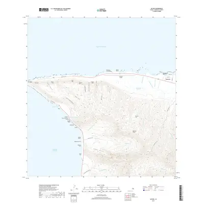
2017 Map of Kaena
USGS Topo · Published 2017About this map
The Wai‘anae Range dominates the westernmost reaches of Oahu, where sharp ridges and deep gulches like Alau Gulch and Kaiahi Gulch drop precipitously toward the northern and western shores. This landscape is defined by the tension between the steep, inland palis and the coastal flats that host Mokulē‘ia and the operational Dillingham Airfield. The geography transitions from the rugged heights of Peacock Flat to the iconic shoreline of Yokohama Bay, connected by the winding Farrington Hwy.
Find a feature on this map
49 named features on this map. Tap any name to fly to it.
Don’t see what you’re looking for? This feature index may not catch every label — zoom into the map to look around manually.
Map Details
Editions of this 2017 Kaena Map
This is the sole edition of this map. No revisions or reprints were ever made.
Other maps of this area

1952 · Waimea
USGS Topo · 1:24,000

1953 · Haleiwa
USGS Topo · 1:24,000

1953 · Schofield Barracks
USGS Topo · 1:24,000

1954 · Oahu
USGS Topo · 1:250,000

1954 · Waianae
USGS Topo · 1:24,000

1954 · Kaena
USGS Topo · 1:24,000

1960 · Haleiwa
USGS Topo · 1:24,000

1960 · Schofield Barracks
USGS Topo · 1:24,000

1961 · Oahu
USGS Topo · 1:250,000
1963 · Waianae
USGS Topo · 1:24,000