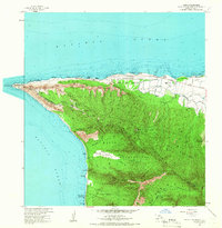
1964 Map of Kaena
USGS Topo · Published 1966About this map
Kaena Point anchors the westernmost tip of Oahu in this mid-century survey, a landscape defined by sharp coastal palis and extensive military footprints. The Dillingham Air Force Base dominates the northern coast near Mokuleia Beach, while the interior is carved into several managed forest reserves including Kuaokala Forest Reserve and Makaha Forest Reserve. Evidence of the island's ranching history is visible through named properties such as Crowbar Ranch and Dillingham Ranch, positioned along the Old Railroad Grade and Farrington Highway. Cultural and archaeological sites are also noted, including the Heiau and Kaneana Cave along the southwestern shore. The map illustrates a transitional era for the Waianae Mountains, where traditional land use and large-scale ranching met expanding defensive installations like the Makua Military Reservation.
Find a feature on this map
61 named features on this map. Tap any name to fly to it.
Don’t see what you’re looking for? This feature index may not catch every label — zoom into the map to look around manually.
Map Details
Editions of this 1964 Kaena Map
This is the sole edition of this map. No revisions or reprints were ever made.
Other maps of this area

1952 · Waimea
USGS Topo · 1:24,000

1953 · Haleiwa
USGS Topo · 1:24,000

1953 · Schofield Barracks
USGS Topo · 1:24,000

1954 · Oahu
USGS Topo · 1:250,000

1954 · Waianae
USGS Topo · 1:24,000

1954 · Kaena
USGS Topo · 1:24,000

1960 · Haleiwa
USGS Topo · 1:24,000

1960 · Schofield Barracks
USGS Topo · 1:24,000

1961 · Oahu
USGS Topo · 1:250,000
1963 · Waianae
USGS Topo · 1:24,000