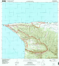
1998 Map of Kaena
USGS Topo · Published 2000About this map
Ka'ena Point marks the westernmost tip of O'ahu, where the rugged terrain of the Wai'anae Range meets the Pacific Ocean. This late-twentieth-century survey illustrates a landscape primarily defined by vast conservation areas and military installations, such as the Makua Military Reservation and Dillingham Military Reservation. Along the northern coast, the transition from ranching heritage to modern recreation is evident at the Dillingham Ranch and Mokule'ia Beach Park. Significant elevation changes are depicted through numerous gulches like Keekee Gulch and Manini Gulch, which carve through the Kuaokala Forest Reserve. The southern portion of the quadrangle shows the established Kea'au Homesteads and the site of Mākua, offering a detailed look at the island's land divisions between the Waialua District and Wai'anae District.
Find a feature on this map
67 named features on this map. Tap any name to fly to it.
Don’t see what you’re looking for? This feature index may not catch every label — zoom into the map to look around manually.
Map Details
Editions of this 1998 Kaena Map
This is the sole edition of this map. No revisions or reprints were ever made.
Other maps of this area

1952 · Waimea
USGS Topo · 1:24,000

1953 · Haleiwa
USGS Topo · 1:24,000

1953 · Schofield Barracks
USGS Topo · 1:24,000

1954 · Oahu
USGS Topo · 1:250,000

1954 · Waianae
USGS Topo · 1:24,000

1954 · Kaena
USGS Topo · 1:24,000

1960 · Haleiwa
USGS Topo · 1:24,000

1960 · Schofield Barracks
USGS Topo · 1:24,000

1961 · Oahu
USGS Topo · 1:250,000
1963 · Waianae
USGS Topo · 1:24,000