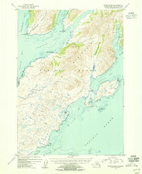
1954 Map of Kaguyak D-6
USGS Topo · Published 1955About this map
Kaguyak sits on the eastern shoreline of the Aliulik Peninsula in this mid-century study of Kodiak Island. The landscape is dominated by the deep incisions of the Pacific Ocean, where Kaguyak Bay and Old Kaguyak Bay meet a coastline marked by prominent features like Cape Kaguyak and Boot Pt. To the north, the Hepburn Peninsula divides Deadman Bay from Sulua Bay, leading into the sheltered waters of Portage Bay. While the interior is largely defined by the high elevations of Humpy Cone and the surrounding peaks, the map identifies small signs of human activity including a Cabin near Shag Bluff and another on the shores of Sulua Bay. This survey was conducted when the entire land area was already integrated into the Kodiak National Wildlife Refuge, preserving a snapshot of the region's complex maritime geography before significant modern changes.
Find a feature on this map
41 named features on this map. Tap any name to fly to it.
Don’t see what you’re looking for? This feature index may not catch every label — zoom into the map to look around manually.
Map Details
Editions of this 1954 Kaguyak D-6 Map
This is the sole edition of this map. No revisions or reprints were ever made.
Other maps of this area

1951 · Kaguyak
USGS Topo · 1:250,000

1951 · Trinity Islands
USGS Topo · 1:250,000

1951 · Karluk
USGS Topo · 1:250,000

1952 · Kodiak
USGS Topo · 1:250,000

1952 · Kaguyak
USGS Topo · 1:250,000

1952 · Karluk
USGS Topo · 1:250,000

1952 · Kaguyak D-5
USGS Topo · 1:63,360

1952 · Trinity Islands D-1
USGS Topo · 1:63,360

1952 · Karluk A-1
USGS Topo · 1:63,360

1952 · Kaguyak D-6
USGS Topo · 1:63,360