
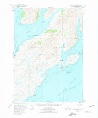
1952 Map of Kaguyak D-6
USGS Topo · Published 1972About this map
Kaguyak sits as a primary point of human presence on this portion of the southeastern Kodiak Island coastline, situated at the entrance to Aguyak Bay. The landscape is defined by its complex maritime geography, where the Hepburn Peninsula divides the deep waters of Deadman Bay from the more sheltered Portage Bay. Smaller indentations like Humpy Cove and Seaborg Bay along the Alitak Bay coast suggest a shoreline shaped by both tidal action and glacial legacy. The map records several isolated Cabin sites and significant coastal markers such as Cape Kaguyak and Boot Pt. To the south, the Geese Channel provides a passage between the main island and the outer waters of the Pacific Ocean, while labels like Old Kaguyak Bay indicate the shifting locales of local habitation and maritime activity during this mid-century period.
Find a feature on this map
27 named features on this map. Tap any name to fly to it.
Don’t see what you’re looking for? This feature index may not catch every label — zoom into the map to look around manually.
Map Details
Editions of this 1952 Kaguyak D-6 Map
2 editions found
Other maps of this area

1951 · Kaguyak
USGS Topo · 1:250,000

1951 · Trinity Islands
USGS Topo · 1:250,000

1951 · Karluk
USGS Topo · 1:250,000

1952 · Kodiak
USGS Topo · 1:250,000

1952 · Kaguyak
USGS Topo · 1:250,000

1952 · Karluk
USGS Topo · 1:250,000

1952 · Kaguyak D-5
USGS Topo · 1:63,360

1952 · Trinity Islands D-1
USGS Topo · 1:63,360

1952 · Karluk A-1
USGS Topo · 1:63,360

1952 · Kodiak A-6
USGS Topo · 1:63,360