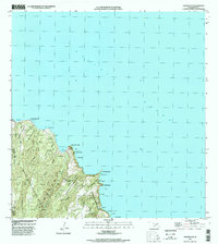
1997 Map of Kahakuloa
USGS Topo · Published 1999About this map
Kahakuloa and its surrounding coastal lands are defined by a succession of steep gulches and prominent headlands along the northern Maui coast. The landscape transition from the high ridges of the West Maui Forest Reserve down to the Pacific Ocean is marked by deep incisions like Kahakuloa Gulch and Hononana Gulch. This 1990s era survey documents the local land divisions including the Kahakuloa Homesteads and smaller settlement areas at Lahoole and Aawanui. Notable coastal landmarks such as the sheer Kahakuloa Head and Puu Koae dominate the shoreline, while inland features like the Gaging Station on Kahakuloa Stream indicate the management of vital water resources in this steep, tropical environment.
Find a feature on this map
44 named features on this map. Tap any name to fly to it.
Don’t see what you’re looking for? This feature index may not catch every label — zoom into the map to look around manually.
Map Details
Editions of this 1997 Kahakuloa Map
This is the sole edition of this map. No revisions or reprints were ever made.
Other maps of this area

1954 · Maui
USGS Topo · 1:250,000

1954 · Paia
USGS Topo · 1:24,000

1955 · Wailuku
USGS Topo · 1:24,000

1955 · Kahakuloa
USGS Topo · 1:24,000

1956 · Lahaina
USGS Topo · 1:24,000

1956 · Honolua
USGS Topo · 1:24,000

1966 · Maui
USGS Topo · 1:250,000

1974 · Maui
USGS Topo · 1:250,000
1977 · Paia
USGS Topo · 1:24,000

1977 · Wailuku
USGS Topo · 1:24,000