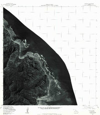
1978 Map of Kahana
USGS Topo · Published 1984About this map
Kahana and the coastal settlement of Kaaawa occupy the windward shoreline of Oahu as captured in this late 1970s orthophotoquad. Produced through optical scanning of aerial photography, this imagery emphasizes the sharp relief of the coastal mountain ridges and the expansive coral reef structures extending into the Pacific Ocean. The transition from the steep, vegetated valleys of the interior to the narrow coastal strip reveals the concentrated settlement patterns along the shore, reaching down to the northern edge of Kaneohe Bay. At the center of the coastline, Kaoio Point serves as a prominent natural landmark where the mountains meet the sea, providing a clear visual record of the island's topography and coastal development during this era of land resource documentation.
Find a feature on this map
5 named features on this map. Tap any name to fly to it.
Don’t see what you’re looking for? This feature index may not catch every label — zoom into the map to look around manually.
Map Details
Editions of this 1978 Kahana Map
This is the sole edition of this map. No revisions or reprints were ever made.
Other maps of this area

1952 · Mokapu
USGS Topo · 1:24,000

1953 · Hauula
USGS Topo · 1:24,000

1954 · Oahu
USGS Topo · 1:250,000

1954 · Kahuku
USGS Topo · 1:24,000

1954 · Kahana
USGS Topo · 1:24,000

1954 · Kaneohe
USGS Topo · 1:24,000

1954 · Waipahu
USGS Topo · 1:24,000

1959 · Mokapu
USGS Topo · 1:24,000

1959 · Kaneohe
USGS Topo · 1:24,000

1959 · Waipahu
USGS Topo · 1:24,000