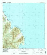
1992 Map of Kahana
USGS Topo · Published 2001About this map
The windward coast of Oahu is defined here by the deep incision of Kahana Valley and a series of coastal settlements linked by the Kamehameha Highway. In the early 1990s, the landscape retains its traditional coastal character, featuring significant cultural and agricultural landmarks such as Huila Pond and the large Mōli'i Pond near the District boundary. The map illustrates a transition from the narrow coastal shelf of Ka'a'awa and Punalu'u to the steep interior peaks of Pu'umanamana and Haloa. Notable local infrastructure includes the Ka'a'awa School, a coastal Seawall, and a Gaging Station monitoring the Kahana Stream. Small settlements like Waikane Camp and Hale'aha sit between the shoreline and the sheer valley walls, while offshore features like Mokoli'i Island and the famous Crouching Lion rock formation provide distinct navigational and cultural markers.
Find a feature on this map
54 named features on this map. Tap any name to fly to it.
Don’t see what you’re looking for? This feature index may not catch every label — zoom into the map to look around manually.
Map Details
Editions of this 1992 Kahana Map
This is the sole edition of this map. No revisions or reprints were ever made.
Other maps of this area

1952 · Mokapu
USGS Topo · 1:24,000

1953 · Hauula
USGS Topo · 1:24,000

1954 · Oahu
USGS Topo · 1:250,000

1954 · Kahuku
USGS Topo · 1:24,000

1954 · Kahana
USGS Topo · 1:24,000

1954 · Kaneohe
USGS Topo · 1:24,000

1954 · Waipahu
USGS Topo · 1:24,000

1959 · Mokapu
USGS Topo · 1:24,000

1959 · Kaneohe
USGS Topo · 1:24,000

1959 · Waipahu
USGS Topo · 1:24,000