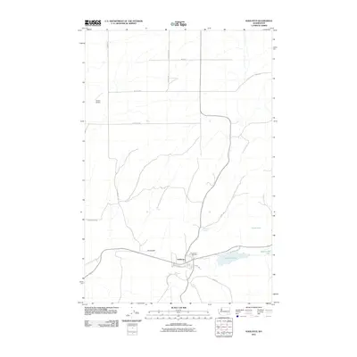
2011 Map of Kahlotus
USGS Topo · Published 2011About this map
Kahlotus sits at the junction of the area's primary transportation routes, where Pasco Kahlotus Rd and several local connectors meet. The settlement is defined by its proximity to Lake Kahlotus and the neighboring Washtucna Lake, which lie in a distinct Coulee depression. The rural character of this Franklin County landscape is evidenced by the network of family-named roads, such as S Longmeier Rd and Reeves Rd, stretching across the plateau north of the town.
Find a feature on this map
24 named features on this map. Tap any name to fly to it.
Don’t see what you’re looking for? This feature index may not catch every label — zoom into the map to look around manually.
Map Details
Editions of this 2011 Kahlotus Map
This is the sole edition of this map. No revisions or reprints were ever made.
Other maps of this area

1916 · Connell
USGS Topo · 1:125,000

1918 · Connell
USGS Topo · 1:125,000

1923 · Washtucna
USGS Topo · 1:62,500

1925 · Washtucna
USGS Topo · 1:62,500

1948 · Ayer
USGS Topo · 1:62,500

1950 · Haas
USGS Topo · 1:62,500

1953 · Walla Walla
USGS Topo · 1:250,000

1958 · Walla Walla
USGS Topo · 1:250,000
1970 · Burr Canyon
USGS Topo · 1:24,000
1970 · Lower Monumental Dam
USGS Topo · 1:24,000