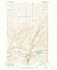
1970 Map of Kahlotus
USGS Topo · Published 1973About this map
Kahlotus sits at the junction of significant regional infrastructure and rugged topography in this early 1970s survey of eastern Franklin County. The landscape is defined by the high, flat reaches of Michigan Prairie and the Sand Hills to the north, which give way to the dramatic depression of a steep-walled Coulee. This geologic feature contains Lake Kahlotus, a prominent water body flanked by the Union Pacific and Burlington Northern railroads. These parallel rail lines underscore the town's historical importance as a transit corridor between the channeled scablands and the Snake River to the south.
Find a feature on this map
35 named features on this map. Tap any name to fly to it.
Don’t see what you’re looking for? This feature index may not catch every label — zoom into the map to look around manually.
Map Details
Editions of this 1970 Kahlotus Map
This is the sole edition of this map. No revisions or reprints were ever made.
Other maps of this area

1916 · Connell
USGS Topo · 1:125,000

1918 · Connell
USGS Topo · 1:125,000

1923 · Washtucna
USGS Topo · 1:62,500

1925 · Washtucna
USGS Topo · 1:62,500

1948 · Ayer
USGS Topo · 1:62,500

1950 · Haas
USGS Topo · 1:62,500

1953 · Walla Walla
USGS Topo · 1:250,000

1958 · Walla Walla
USGS Topo · 1:250,000
1970 · Burr Canyon
USGS Topo · 1:24,000
1970 · Lower Monumental Dam
USGS Topo · 1:24,000