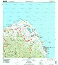
1998 Map of Kahuku
USGS Topo · Published 2000About this map
Kamehameha Highway traces the North Shore of Oahu, connecting a landscape defined by coastal settlements and extensive military and conservation lands. The late 20th-century development of La'ie is anchored by Brigham Young University, the La'ie Temple, and the Polynesian Cultural Center, marking it as a significant cultural and educational hub. Further north, the town of Kahuku is situated between the coast and the rising terrain of the Ko'olau Range, featuring local infrastructure like Kahuku Hospital and an Aquaculture Site.
Find a feature on this map
69 named features on this map. Tap any name to fly to it.
Don’t see what you’re looking for? This feature index may not catch every label — zoom into the map to look around manually.
Map Details
Editions of this 1998 Kahuku Map
This is the sole edition of this map. No revisions or reprints were ever made.
Other maps of this area

1952 · Waimea
USGS Topo · 1:24,000

1953 · Haleiwa
USGS Topo · 1:24,000

1953 · Hauula
USGS Topo · 1:24,000

1954 · Oahu
USGS Topo · 1:250,000

1954 · Kahuku
USGS Topo · 1:24,000

1954 · Kahana
USGS Topo · 1:24,000

1960 · Haleiwa
USGS Topo · 1:24,000

1961 · Oahu
USGS Topo · 1:250,000

1965 · Oahu
USGS Topo · 1:250,000
1965 · Kahuku
USGS Topo · 1:24,000