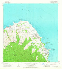
1965 Map of Kahuku
USGS Topo · Published 1967About this map
Kahuku Pt serves as the northernmost anchor for this coastal survey of Oahu, where the agricultural and religious heritage of the North Shore is clearly visible. The landscape is defined by the transition from the Koolau Range and the Kahuku Forest Reserve down to the coastal plains. Near the settlement of Laie, the map shows the prominent Laie Temple alongside the Church College of Hawaii and the Polynesian Cultural Center, marking this area as a significant cultural and educational hub. Industrial and military history is etched into the land via the Old Railroad Grade and the Kahuku Airfield, while the shoreline is dotted with numerous bird refuges like Kihewamoku I and Mokuaia I. Inland, a complex network of flumes, pumping stations, and an aqueduct illustrates the sophisticated water management systems required for the region's plantation-era development.
Find a feature on this map
90 named features on this map. Tap any name to fly to it.
Don’t see what you’re looking for? This feature index may not catch every label — zoom into the map to look around manually.
Map Details
Editions of this 1965 Kahuku Map
2 editions found
Other maps of this area

1952 · Waimea
USGS Topo · 1:24,000

1953 · Haleiwa
USGS Topo · 1:24,000

1953 · Hauula
USGS Topo · 1:24,000

1954 · Oahu
USGS Topo · 1:250,000

1954 · Kahuku
USGS Topo · 1:24,000

1954 · Kahana
USGS Topo · 1:24,000

1960 · Haleiwa
USGS Topo · 1:24,000

1961 · Oahu
USGS Topo · 1:250,000

1965 · Oahu
USGS Topo · 1:250,000
1966 · Waimea
USGS Topo · 1:24,000