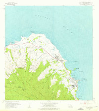
1965 Map of Kahuku
USGS Topo · Published 1975About this map
Kahuku and the northern tip of Oahu are defined by a complex irrigation and industrial network during the mid-1960s. The landscape is etched with numerous gulches, such as Hanakaoe Gulch and Malaekahana Gulch, which feed a series of water management systems including several Pumping Station sites and an extensive Aqueduct. Transport history is visible through the Old Railroad Grade that skirts the coast near Kahuku Pt, a remnant of the region's plantation-era logistics.
Find a feature on this map
72 named features on this map. Tap any name to fly to it.
Don’t see what you’re looking for? This feature index may not catch every label — zoom into the map to look around manually.
Map Details
Editions of this 1965 Kahuku Map
2 editions found
Other maps of this area

1952 · Waimea
USGS Topo · 1:24,000

1953 · Haleiwa
USGS Topo · 1:24,000

1953 · Hauula
USGS Topo · 1:24,000

1954 · Oahu
USGS Topo · 1:250,000

1954 · Kahuku
USGS Topo · 1:24,000

1954 · Kahana
USGS Topo · 1:24,000

1960 · Haleiwa
USGS Topo · 1:24,000

1961 · Oahu
USGS Topo · 1:250,000

1965 · Oahu
USGS Topo · 1:250,000
1965 · Kahuku
USGS Topo · 1:24,000