1988 Map of Kaibab
USGS Topo · Published 1990About this map
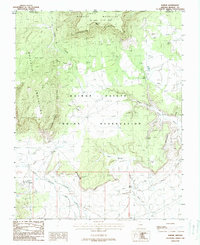
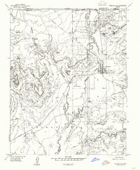
Kaibab - Paiute Indian Reservation land dominates this high-desert landscape along the Arizona-Utah border, centered on the settlement of Kaibab. The geography is defined by massive escarpments, including the Vermilion Cliffs and the Shinarump Cliffs, which create a rugged staircase of plateaus. Human activity is closely tied to water sources like Clear Water Spring and Wolf Spring, essential outposts in a territory carved by drainages such as Sandy Wash and Twomile Wash. The map records essential community landmarks like a Cem northwest of the main townsite, while natural features like Cedar Ridge and the Moccasin Mountains illustrate the complex elevation changes of the Colorado Plateau. This 1980s survey provides a detailed look at the intersection of Mohave and Kane counties within the tribal lands.
Find a feature on this map
25 named features on this map. Tap any name to fly to it.
Don’t see what you’re looking for? This feature index may not catch every label — zoom into the map to look around manually.
Map Details
Editions of this 1988 Kaibab Map
This is the sole edition of this map. No revisions or reprints were ever made.
Other maps of this area

1886 · Kanab
USGS Topo · 1:250,000

1886 · Kaibab
USGS Topo · 1:250,000

1953 · Cedar City
USGS Topo · 1:250,000

1953 · Grand Canyon
USGS Topo · 1:250,000

1954 · Kanab SW
USGS Topo · 1:24,000
1954 · Fredonia NW
USGS Topo · 1:24,000

1954 · Kanab SE
USGS Topo · 1:24,000
1954 · Short Creek SE
USGS Topo · 1:24,000
1954 · Fredonia SW
USGS Topo · 1:24,000
1954 · Fredonia NE
USGS Topo · 1:24,000