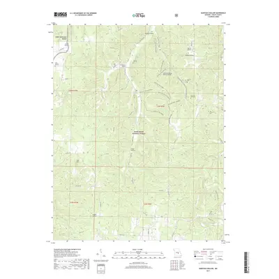
2017 Map of Kaintuck Hollow
USGS Topo · Published 2017About this map
Mark Twain National Forest dominates this section of the Missouri Ozarks, where deep drainages and spring-fed creeks define the rugged topography south of the Fort Leonard Wood military reservation. The landscape is characterized by a network of named hollows, including Smith Hollow, Hardester Hollow, and Milldam Hollow, which funnel water toward the perennial Mill Creek. A significant system of forest trails, such as the Kaintuck Trail Deer Track and Kaintuck Trail Acorn, provides access to the interior terrain, notably passing the Kaintuck Hollow Natural Bridge. This 2017 survey reveals a scattered settlement pattern of family cemeteries and small rural plots tucked into the valleys. Genealogists and local historians can locate numerous burial sites across the quadrangle, from the Cook Western Star Cem in the west to the Yowell Cem on the eastern boundary, illustrating the long-standing community ties to these specific Missouri hillsides.
Find a feature on this map
52 named features on this map. Tap any name to fly to it.
Don’t see what you’re looking for? This feature index may not catch every label — zoom into the map to look around manually.
Map Details
Editions of this 2017 Kaintuck Hollow Map
This is the sole edition of this map. No revisions or reprints were ever made.
Other maps of this area

1912 · Rolla
USGS Topo · 1:62,500

1936 · Waynesville
USGS Topo · 1:48,000

1937 · Edgar Springs
USGS Topo · 1:48,000

1941 · Big Piney
USGS Topo · 1:62,500

1942 · Waynesville
USGS Topo · 1:62,500

1943 · Big Piney
USGS Topo · 1:62,500

1944 · Waynesville
USGS Topo · 1:62,500

1945 · Edgar Springs
USGS Topo · 1:62,500

1949 · Rolla
USGS Topo · 1:250,000

1950 · Newburg
USGS Topo · 1:24,000