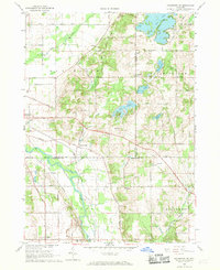
1967 Map of Kalamazoo NE
USGS Topo · Published 1969About this map
The Kalamazoo River and the Penn Central railroad corridor anchor this landscape at the intersection of Allegan, Barry, and Kalamazoo counties. In the late 1960s, the area reflects a mix of traditional agricultural road grids, such as 104th Avenue and Base Line Road, alongside burgeoning recreational developments like the Lake Doster Golf Club and Camp Merrie Woode. Small settlements and transit points including Doster, Neeley, and Cressey are interspersed among numerous water bodies, including Pine Lake and Warner Lake. For genealogists and local historians, the sheet preserves the locations of several burial grounds, including Ives Cem, Hillside Cem, and East Cooper Cem, providing a clear record of the rural community's footprint before late-century suburban expansion reached these townships.
Find a feature on this map
49 named features on this map. Tap any name to fly to it.
Don’t see what you’re looking for? This feature index may not catch every label — zoom into the map to look around manually.
Map Details
Editions of this 1967 Kalamazoo NE Map
4 editions found
Other maps of this area

1916 · Kalamazoo
USGS Topo · 1:62,500

1918 · Kalamazoo
USGS Topo · 1:62,500

1918 · Galesburg
USGS Topo · 1:62,500

1943 · Kalamazoo
USGS Topo · 1:62,500

1944 · Galesburg
USGS Topo · 1:62,500

1947 · Delton
USGS Topo · 1:24,000

1947 · Galesburg
USGS Topo · 1:24,000

1947 · Galesburg
USGS Topo · 1:62,500

1950 · Galesburg
USGS Topo · 1:62,500

1951 · Hastings
USGS Topo · 1:62,500