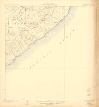
1924 Map of Kalapana
USGS Topo · Published 1924About this map
Lava Flow patterns and volcanic craters define the landscape of Hawaii's southeastern coast during the governorship of Wallace R. Farrington. This 1922 survey documents an era of extensive agricultural partitioning, visible in the numerous land grants like the Kaniahiku Homesteads and Malama Homesteads that stretch from the interior toward the Pacific Ocean. The map shows established settlements such as Pahoa, Kapoho, and the coastal village of Kalapana, providing a precise record of these communities before later volcanic activity altered the Puna District topography.
Find a feature on this map
90 named features on this map. Tap any name to fly to it.
Don’t see what you’re looking for? This feature index may not catch every label — zoom into the map to look around manually.
Map Details
Editions of this 1924 Kalapana Map
4 editions found
Other maps of this area

1917 · Hilo
USGS Topo · 1:62,500

1922 · Puna
USGS Topo · 1:62,500

1924 · Makuu
USGS Topo · 1:62,500

1924 · Puna
USGS Topo · 1:62,500

1924 · Kalapana
USGS Topo · 1:62,500

1932 · Hilo
USGS Topo · 1:62,500

1954 · Hawaii South
USGS Topo · 1:250,000

1954 · Hawaii North
USGS Topo · 1:250,000

1959 · Hawaii South
USGS Topo · 1:250,000

1959 · Hawaii North
USGS Topo · 1:250,000