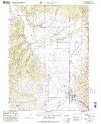
1998 Map of Kamas
USGS Topo · Published 2001About this map
Kamas Valley serves as a vital corridor between the high peaks of the Wasatch National Forest and the fertile lowlands along the Weber River. This late-twentieth-century revision reveals a landscape defined by traditional settlement patterns and water management, centered on the towns of Kamas, Oakley, and Peoa. Local history is preserved through a series of family and community landmarks, including the Oakley Cem, Stevens Cem, and Marion Cem. The mapping highlights the critical role of irrigation and water control in this high-altitude valley, most notably through the Provo River Diversion Canal and various tributaries like Beaver Creek and Thorn Spring Creek. Education and community life are anchored at the South Summit High Sch, while small-scale industrial activity is marked by a Gravel Pit and other extractive sites near the western foothills of the Mahogany Hills.
Find a feature on this map
33 named features on this map. Tap any name to fly to it.
Don’t see what you’re looking for? This feature index may not catch every label — zoom into the map to look around manually.
Map Details
Editions of this 1998 Kamas Map
This is the sole edition of this map. No revisions or reprints were ever made.
Other maps of this area

1885 · Salt Lake
USGS Topo · 1:250,000

1900 · Coalville
USGS Topo · 1:125,000

1903 · Coalville
USGS Topo · 1:125,000

1954 · Salt Lake City
USGS Topo · 1:250,000

1955 · Heber
USGS Topo · 1:24,000

1955 · Park City East
USGS Topo · 1:24,000

1958 · Salt Lake City
USGS Topo · 1:250,000

1960 · Salt Lake City
USGS Topo · 1:250,000

1967 · Francis
USGS Topo · 1:24,000

1967 · Kamas
USGS Topo · 1:24,000