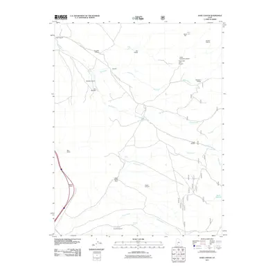
2011 Map of Kane Canyon
USGS Topo · Published 2011About this map
Coxs Ranch sits at a focal point of this high-desert landscape, where local drainage networks and primitive roads converge in the eastern reaches of Iron County. The map details an intricate system of water management and natural hydrology, featuring Rocky Reservoir, seasonal springs like Lees Spring and Sand Cliff Spring, and the prominent South Creek corridor. The geography is defined by significant relief, from the heights of Beaver Ridge overlooking Blue Valley to the confined passages of The Narrows and Boulder Canyon. A network of unpaved routes, including the Coyote Bench Loop and South Creek Rd, provides the primary access through this complex terrain of washes and hollows, such as Wide Mouth Wash and Patterson Hollow. This 2011 survey documents the essential land-use patterns of the region, emphasizing the sparse but critical ranching infrastructure and water sources that sustain activity in this arid environment.
Find a feature on this map
33 named features on this map. Tap any name to fly to it.
Don’t see what you’re looking for? This feature index may not catch every label — zoom into the map to look around manually.
Map Details
Editions of this 2011 Kane Canyon Map
This is the sole edition of this map. No revisions or reprints were ever made.
Other maps of this area

1885 · Beaver
USGS Topo · 1:250,000

1937 · Delano Peak
USGS Topo · 1:48,000

1943 · Delano Peak
USGS Topo · 1:62,500

1953 · Richfield
USGS Topo · 1:250,000

1954 · Beaver SE
USGS Topo · 1:24,000

1958 · Richfield
USGS Topo · 1:250,000

1958 · Beaver
USGS Topo · 1:62,500

1966 · Fremont Pass
USGS Topo · 1:24,000

1971 · Buckhorn Flat
USGS Topo · 1:24,000
1971 · Burnt Peak
USGS Topo · 1:24,000