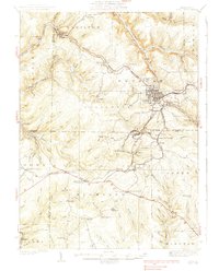
1939 Map of Kane
USGS Topo · Published 1939About this map
Kane serves as the industrial and transit anchor for this 1930s survey of the Allegheny Plateau, where the Pennsylvania and Baltimore and Ohio railroads converge to move timber and minerals. The landscape is defined by the deep incision of Tionesta Creek and its many branches, including the West Branch and East Branch. These valleys are dotted with company towns and shipping points like Brookston and James City. Local life is recorded through features such as Northwestern Sch and Greendale Sch, while the presence of a CCC Camp and Fire Tower at Highland Corners reflects Depression-era conservation efforts. Distinctive local names like Pigs Ear and Windy City sit alongside specialized sites like Crystal Mineral Springs, illustrating a region transitioning from raw resource extraction to a more diversified rural economy.
Find a feature on this map
95 named features on this map. Tap any name to fly to it.
Don’t see what you’re looking for? This feature index may not catch every label — zoom into the map to look around manually.
Map Details
Editions of this 1939 Kane Map
3 editions found

Other maps of this area

1906 · Warren
USGS Topo · 1:62,500

1907 · Warren
USGS Topo · 1:62,500

1908 · Warren
USGS Topo · 1:62,500

1918 · Loleta
USGS Topo · 1:62,500

1924 · Bradford
USGS Topo · 1:62,500

1926 · Bradford
USGS Topo · 1:62,500

1934 · Kane
USGS Topo · 1:48,000

1935 · Sheffield
USGS Topo · 1:48,000

1935 · Mt. Jewett
USGS Topo · 1:48,000

1936 · Kinzua
USGS Topo · 1:48,000
Featured Places
- Kane, PA
- Sheffield Township, PA
- Wetmore, Hamilton Township
- Sergeant, Wetmore Township
- Lamont, Jones Township