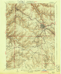
1939 Map of Kane
USGS Topo · Published 1943About this map
The Allegheny National Forest dominates this landscape, surveyed in the mid-1930s to show a region defined by its timber and rail history. The hub of Kane serves as the primary center of commerce, surrounded by numerous smaller industrial and postal settlements like James City, Russell City De Young P.O., and Ludlow. The network of the Baltimore and Ohio railroad weaves through the terrain, connecting remote points such as Sheffield Junction and Durant City Junction. Evidence of the era's social and infrastructure projects is clear with the presence of multiple CCC Camps and local institutions like the Northwestern Sch and Greendale Sch. The map also captures specialized sites like the Crystal Mineral Spring and isolated outposts such as Pigs Ear and Highland Corners, reflecting a time when small-scale settlement was still deeply integrated into the forest economy.
Find a feature on this map
94 named features on this map. Tap any name to fly to it.
Don’t see what you’re looking for? This feature index may not catch every label — zoom into the map to look around manually.
Map Details
Editions of this 1939 Kane Map
3 editions found

Other maps of this area

1906 · Warren
USGS Topo · 1:62,500

1907 · Warren
USGS Topo · 1:62,500

1908 · Warren
USGS Topo · 1:62,500

1918 · Loleta
USGS Topo · 1:62,500

1924 · Bradford
USGS Topo · 1:62,500

1926 · Bradford
USGS Topo · 1:62,500

1934 · Kane
USGS Topo · 1:48,000

1935 · Sheffield
USGS Topo · 1:48,000

1935 · Mt. Jewett
USGS Topo · 1:48,000

1936 · Kinzua
USGS Topo · 1:48,000
Featured Places
- Kane, PA
- Sheffield Township, PA
- Wetmore, Hamilton Township
- Sergeant, Wetmore Township
- Lamont, Jones Township