
1940 Map of Kane Spring
USGS Topo · Published 1956About this map
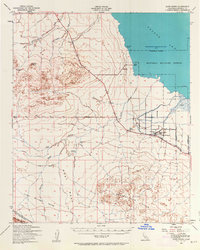
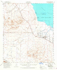
The Salton Sea shoreline dominates the northeast corner of this 1940 survey, where the water surface is recorded at 241 feet below sea level. This desert landscape is defined by its arid hydrology, showing a complex network of seasonal drainages including San Felipe Wash, Tule Wash, and Carrizo Wash. The map documents a period of early 20th-century desert infrastructure, from the Pacific Portland Cement line in the south to the developed leisure spots at Sea View Beach and Sandy Beach. Local history is preserved in the location of the Roosevelt Sch and the Elmore Desert Ranch, while industrial exploration is evident through the Diamond Bar Test Well and Harpers Well. The arid expanse of West Mesa and the Superstition Hills highlights the isolation of these early Imperial County settlements and desert outposts.
Find a feature on this map
27 named features on this map. Tap any name to fly to it.
Don’t see what you’re looking for? This feature index may not catch every label — zoom into the map to look around manually.
Map Details
Editions of this 1940 Kane Spring Map
3 editions found
Other maps of this area

1904 · Indio
USGS Topo · 1:125,000

1915 · El Centro
USGS Topo · 1:125,000

1931 · Vallecito
USGS Topo · 1:125,000

1931 · Carrizo
USGS Topo · 1:125,000

1940 · Brawley
USGS Topo · 1:62,500

1940 · Frink
USGS Topo · 1:62,500

1940 · Plaster City
USGS Topo · 1:62,500

1940 · Durmid
USGS Topo · 1:62,500

1942 · Barrel Spring
USGS Topo · 1:62,500

1942 · Agua Dulce
USGS Topo · 1:62,500