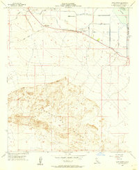
1956 Map of Kane Spring
USGS Topo · Published 1957About this map
The Superstition Hills dominate the southern half of this mid-century survey, rising sharply from a desert floor that sits largely below sea level. This landscape in Imperial County is defined by the intersection of natural arid terrain and intensive mid-century irrigation engineering. To the north, the San Felipe Creek is guided by a Levee system, while a complex grid of water infrastructure including Lateral 7, Drain 21, and a Siphon supports the Elmore Desert Ranch. The map captures the edge of the Salton Sea, featuring the Salton Sea National Wildlife Refuge along the eastern margin. Primitive transportation routes like the Old Spring Trail and the Kane Jeep Road navigate the open ground near Kane Spring, illustrating how travelers and ranchers accessed this challenging environment before further modernization.
Find a feature on this map
20 named features on this map. Tap any name to fly to it.
Don’t see what you’re looking for? This feature index may not catch every label — zoom into the map to look around manually.
Map Details
Editions of this 1956 Kane Spring Map
2 editions found

Other maps of this area

1915 · El Centro
USGS Topo · 1:125,000

1940 · Brawley
USGS Topo · 1:62,500

1940 · Kane Spring
USGS Topo · 1:62,500

1940 · Plaster City
USGS Topo · 1:62,500

1942 · El Centro
USGS Topo · 1:250,000

1943 · Brawley
USGS Topo · 1:62,500

1944 · Plaster City
USGS Topo · 1:62,500

1944 · Kane Spring
USGS Topo · 1:62,500
1944 · Calipatria
USGS Topo · 1:62,500

1954 · El Centro
USGS Topo · 1:250,000