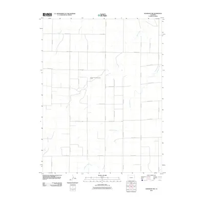
2010 Map of Kanorado NW
USGS Topo · Published 2010About this map
The agrarian landscape of Kit Carson County is defined by its rectilinear grid and the wandering paths of intermittent watercourses. Several tributaries cross this high plains terrain, including Bonny Creek, Beaver Creek, and Little Beaver Creek, which break the otherwise uniform section lines established by a complex network of rural thoroughfares. These routes, ranging from County Road JJ in the north to County Road BB in the south, serve as the primary infrastructure for the region's agricultural operations. One of the most distinctive modern landmarks is the Silkman Farms Incorporated Airport, an isolated private airstrip situated near the confluence of local drainages. This 2010 survey illustrates the continued reliance on the section-line road system for accessing remote farmsteads and managing land use in this corner of eastern Colorado.
Find a feature on this map
22 named features on this map. Tap any name to fly to it.
Don’t see what you’re looking for? This feature index may not catch every label — zoom into the map to look around manually.
Map Details
Editions of this 2010 Kanorado NW Map
This is the sole edition of this map. No revisions or reprints were ever made.
Other maps of this area

1950 · Bonny Reservoir
USGS Topo · 1:62,500

1954 · Limon
USGS Topo · 1:250,000

1957 · Limon
USGS Topo · 1:250,000

1958 · Limon
USGS Topo · 1:250,000

1969 · Kanorado NE
USGS Topo · 1:24,000

1969 · Burlington
USGS Topo · 1:24,000

1969 · Idalia SE
USGS Topo · 1:24,000

1969 · Peconic
USGS Topo · 1:24,000

1969 · Kanorado NW
USGS Topo · 1:24,000
1969 · Burlington NE
USGS Topo · 1:24,000