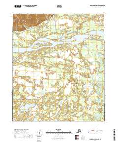
2017 Map of Kantishna River D-2 NE
USGS Topo · Published 2017About this map
Manley Hot Springs serves as the focal point of this Alaskan interior landscape, situated near the confluence of Hot Springs Slough and the Tanana River. The settlement pattern is defined by its proximity to geothermal waters and the vital transport artery of the river system. To the north, the terrain rises sharply into higher elevations where McCloud Ranch Cr drains toward the lowlands. The arrival of the Elliott Highway and the Manley Hot Springs Airport with its Airfield Access road signifies the transition from traditional river-based movement to modern overland and aerial connectivity. This map documents the intricate wetland networks south of the main river channel, where the Zitziana River meanders through a vast complex of ponds and drainage basins typical of the Yukon-Koyukuk region.
Find a feature on this map
12 named features on this map. Tap any name to fly to it.
Don’t see what you’re looking for? This feature index may not catch every label — zoom into the map to look around manually.
Map Details
Editions of this 2017 Kantishna River D-2 NE Map
This is the sole edition of this map. No revisions or reprints were ever made.
Other maps of this area

1948 · Kantishna River
USGS Topo · 1:250,000

1951 · Kantishna River
USGS Topo · 1:250,000

1951 · Tanana
USGS Topo · 1:250,000

1952 · Tanana A-1
USGS Topo · 1:63,360

1952 · Tanana A-2
USGS Topo · 1:63,360

1952 · Kantishna River
USGS Topo · 1:250,000

1952 · Kantishna River D-2
USGS Topo · 1:63,360

1953 · Tanana A-2
USGS Topo · 1:63,360
1953 · Kantishna River D-1
USGS Topo · 1:63,360
1954 · Kantishna River D-1
USGS Topo · 1:63,360