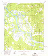
1953 Map of Kantishna River D-1
USGS Topo · Published 1966About this map
The Tanana River dominates this interior Alaskan landscape, characterized by complex braided channels and large landforms like Jennie M Island and Junction Island. To the west, the Zitziana River feeds into the low-lying wetlands, while the northern terrain is defined by the elevation of Giroux Bluff and the Dugan Hills. The map captures a moment in the mid-1950s when human presence was exceptionally sparse, marked only by an isolated Cabin and the path of a Sled Road cutting through the wilderness.
Find a feature on this map
12 named features on this map. Tap any name to fly to it.
Don’t see what you’re looking for? This feature index may not catch every label — zoom into the map to look around manually.
Map Details
Editions of this 1953 Kantishna River D-1 Map
3 editions found
Other maps of this area

1945 · Livengood
USGS Topo · 1:250,000

1948 · Kantishna River
USGS Topo · 1:250,000

1950 · Fairbanks
USGS Topo · 1:250,000

1951 · Kantishna River
USGS Topo · 1:250,000

1951 · Fairbanks
USGS Topo · 1:250,000

1951 · Tanana
USGS Topo · 1:250,000

1951 · Livengood
USGS Topo · 1:250,000

1952 · Tanana A-1
USGS Topo · 1:63,360

1952 · Livengood A-6
USGS Topo · 1:63,360

1952 · Kantishna River C-1
USGS Topo · 1:63,360