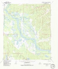
1953 Map of Kantishna River D-1
USGS Topo · Published 1992About this map
The Tanana River dominates this interior Alaskan landscape as it meanders through a network of sloughs and islands, including Jennie M Island and Junction Island. This 1950s survey shows a region defined by its seasonal access and water-based transportation, where the Winter Trail provides essential overland passage across the frozen terrain. To the north, the Dugan Hills rise above the drainage basins of Baker Creek and the Zitziana River. Significant for local history, the map identifies the small settlement of Baker near Giroux Bluff and an isolated Cabin to the southeast. The survey provides a clear look at the intricate wetlands surrounding Kindanina Lake and Iksgiza Lake, illustrating the complex hydrology of the Tanana Valley before modern development altered these remote corridors.
Find a feature on this map
19 named features on this map. Tap any name to fly to it.
Don’t see what you’re looking for? This feature index may not catch every label — zoom into the map to look around manually.
Map Details
Editions of this 1953 Kantishna River D-1 Map
3 editions found
Other maps of this area

1945 · Livengood
USGS Topo · 1:250,000

1948 · Kantishna River
USGS Topo · 1:250,000

1950 · Fairbanks
USGS Topo · 1:250,000

1951 · Kantishna River
USGS Topo · 1:250,000

1951 · Fairbanks
USGS Topo · 1:250,000

1951 · Tanana
USGS Topo · 1:250,000

1951 · Livengood
USGS Topo · 1:250,000

1952 · Tanana A-1
USGS Topo · 1:63,360

1952 · Livengood A-6
USGS Topo · 1:63,360

1952 · Kantishna River C-1
USGS Topo · 1:63,360