1952 Map of Kantishna River D-2
USGS Topo · Published 1966About this map
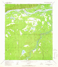
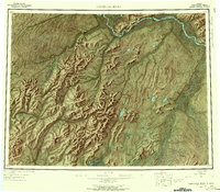
Manley Hot Springs serves as the primary hub for this interior Alaska landscape, situated at the edge of Bean Ridge north of the sprawling river valley. The settlement is connected to the hydrological network through Hot Springs Slough, which bypasses the main channel of the Tanana River to provide access for local transport. Near the village, infrastructure like the Airfield and Hot Springs Landing—complete with a noted Oil Tank—illustrate the logistical challenges of subarctic life during the mid-20th century. The southern portion of the map is dominated by the meandering Zitziana River as it winds through low-lying wetlands toward Bear Lake. These surveyors also noted specific landmarks like the McCloud Ranch Creek and the established Fairbanks Base Line, which provided the essential grid for early territorial land management.
Find a feature on this map
15 named features on this map. Tap any name to fly to it.
Don’t see what you’re looking for? This feature index may not catch every label — zoom into the map to look around manually.
Map Details
Editions of this 1952 Kantishna River D-2 Map
2 editions found

Other maps of this area

1948 · Kantishna River
USGS Topo · 1:250,000

1951 · Kantishna River
USGS Topo · 1:250,000
1951 · Tanana
USGS Topo · 1:250,000
1952 · Tanana A-1
USGS Topo · 1:63,360

1952 · Tanana A-3
USGS Topo · 1:63,360
1952 · Kantishna River C-1
USGS Topo · 1:63,360

1952 · Tanana A-2
USGS Topo · 1:63,360
1952 · Kantishna River
USGS Topo · 1:250,000
1952 · Kantishna River D-3
USGS Topo · 1:63,360
1952 · Kantishna River C-3
USGS Topo · 1:63,360