
1952 Map of Kantishna River C-3
USGS Topo · Published 1970About this map
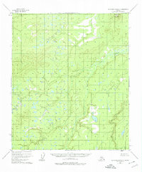
Mooseheart Mountain rises in the northeast corner of this 1952 topographic study, overlooking a vast drainage network dominated by the Zitziana River. This terrain is characterized by a complex system of ponds, lakes, and marshes typical of the Alaskan interior, mapped by the Geological Survey using photogrammetric methods from 1952 aerial photography. The lack of roads or established trails, as noted in the 1969 revisions, highlights the wilderness character of the region during the mid-twentieth century. The land lines shown represent predetermined, unsurveyed locations by the Bureau of Land Management, illustrating how the federal government anticipated future settlement and land use in this unmapped territory. For researchers, the map provides a high-fidelity record of water bodies and elevation contours before more recent environmental changes.
Find a feature on this map
2 named features on this map. Tap any name to fly to it.
Don’t see what you’re looking for? This feature index may not catch every label — zoom into the map to look around manually.
Map Details
Editions of this 1952 Kantishna River C-3 Map
2 editions found
Other maps of this area

1948 · Kantishna River
USGS Topo · 1:250,000

1951 · Kantishna River
USGS Topo · 1:250,000

1952 · Kantishna River
USGS Topo · 1:250,000

1952 · Kantishna River D-2
USGS Topo · 1:63,360

1952 · Kantishna River D-3
USGS Topo · 1:63,360

1952 · Kantishna River C-4
USGS Topo · 1:63,360

1953 · Kantishna River B-2
USGS Topo · 1:63,360

1953 · Kantishna River B-4
USGS Topo · 1:63,360

1953 · Kantishna River B-3
USGS Topo · 1:63,360
1953 · Kantishna River C-2
USGS Topo · 1:63,360