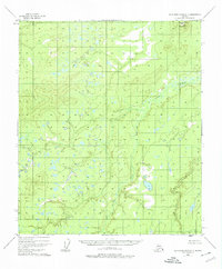
1952 Map of Kantishna River C-3
USGS Topo · Published 1974About this map
Mooseheart Mountain stands as the primary topographical landmark in this interior Alaskan wilderness, reaching an elevation of over 1,200 feet in the northeast. The surrounding landscape is defined by the winding course of the Zitziana River, which flows through a complex network of wetlands, small lakes, and marshes. Surveyed in 1952 using aerial photography, the map reveals a roadless environment where natural watercourses dictated travel and survival. The dense concentration of swamp symbols across the terrain highlights the seasonal challenges of the Yukon-Koyukuk region, while the absence of any named settlements or man-made infrastructure underscores the isolation of this reach of the Zitziana River valley during the mid-20th century.
Find a feature on this map
2 named features on this map. Tap any name to fly to it.
Don’t see what you’re looking for? This feature index may not catch every label — zoom into the map to look around manually.
Map Details
Editions of this 1952 Kantishna River C-3 Map
2 editions found
Other maps of this area

1948 · Kantishna River
USGS Topo · 1:250,000

1951 · Kantishna River
USGS Topo · 1:250,000

1952 · Kantishna River
USGS Topo · 1:250,000

1952 · Kantishna River D-2
USGS Topo · 1:63,360

1952 · Kantishna River D-3
USGS Topo · 1:63,360

1952 · Kantishna River C-3
USGS Topo · 1:63,360

1952 · Kantishna River C-4
USGS Topo · 1:63,360

1953 · Kantishna River B-2
USGS Topo · 1:63,360

1953 · Kantishna River B-4
USGS Topo · 1:63,360

1953 · Kantishna River B-3
USGS Topo · 1:63,360