
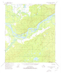
1952 Map of Kantishna River D-3
USGS Topo · Published 1967About this map
The confluence of major Alaskan waterways dominates this interior landscape, where the Kantishna River and Cosna River join the massive Tanana River. This 1950s-era topography documents a wilderness corridor defined by complex hydrological systems, including Williams Slough and Vacho Slough, which weave through the lowlands around Vacho Island. The map records the location of Cosna (site) and Coskakat, providing essential coordinates for researchers interested in early riverine settlements and indigenous travel routes before more modern infrastructure reached the region.
Find a feature on this map
16 named features on this map. Tap any name to fly to it.
Don’t see what you’re looking for? This feature index may not catch every label — zoom into the map to look around manually.
Map Details
Editions of this 1952 Kantishna River D-3 Map
2 editions found
Other maps of this area

1948 · Kantishna River
USGS Topo · 1:250,000

1951 · Kantishna River
USGS Topo · 1:250,000

1951 · Tanana
USGS Topo · 1:250,000

1952 · Tanana A-3
USGS Topo · 1:63,360

1952 · Tanana A-2
USGS Topo · 1:63,360

1952 · Tanana A-4
USGS Topo · 1:63,360

1952 · Kantishna River
USGS Topo · 1:250,000

1952 · Kantishna River D-2
USGS Topo · 1:63,360

1952 · Kantishna River C-3
USGS Topo · 1:63,360

1952 · Kantishna River C-4
USGS Topo · 1:63,360