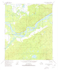
1952 Map of Kantishna River D-3
USGS Topo · Published 1980About this map
The confluence of the Tanana River and Cosna River anchors this mid-century topographic study, revealing a complex landscape of shifting waterways and remote outposts. The interior Alaskan terrain is defined by the prominent Bean Ridge rising to the north and the isolated peak of Mooseheart Mtn in the south. Along the riverbanks, small signs of human activity appear at Cosna and Cos Jacket, indicating the transient nature of riverside life in this region. Numerous braided channels and sloughs, including Williams Slough and Cosna Slough, wind around large river features like Vachon Island. The map also captures the Fairbanks Base Line as it intersects the Cosna Bluff, providing a glimpse into the surveying infrastructure used to map this largely roadless territory during the early 1950s.
Find a feature on this map
14 named features on this map. Tap any name to fly to it.
Don’t see what you’re looking for? This feature index may not catch every label — zoom into the map to look around manually.
Map Details
Editions of this 1952 Kantishna River D-3 Map
2 editions found
Other maps of this area

1948 · Kantishna River
USGS Topo · 1:250,000

1951 · Kantishna River
USGS Topo · 1:250,000

1951 · Tanana
USGS Topo · 1:250,000

1952 · Tanana A-3
USGS Topo · 1:63,360

1952 · Tanana A-2
USGS Topo · 1:63,360

1952 · Tanana A-4
USGS Topo · 1:63,360

1952 · Kantishna River
USGS Topo · 1:250,000

1952 · Kantishna River D-2
USGS Topo · 1:63,360

1952 · Kantishna River D-3
USGS Topo · 1:63,360

1952 · Kantishna River C-3
USGS Topo · 1:63,360