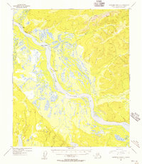
1954 Map of Kantishna River D-1
USGS Topo · Published 1956About this map
The Tanana River dominates this mid-century Alaskan landscape, its braided channels and shifting sandbars creating a complex hydrologic network through the Yukon-Koyukuk region. Large river features such as Jennie M Island and Junction Island are prominent within the flow, while the northern bank is defined by the steep elevation of Giroux Bluff. Evidence of seasonal overland travel is visible in the form of a Sled Road that traverses the northern terrain, connecting various points of interest along the water. The confluence of the Zitziana River and Baker Creek with the main channel further illustrates the river-dependent geography of the era. A solitary Cabin located downstream suggests the sparse, localized settlement pattern typical of the interior during the 1950s, where movement relied heavily on these waterway corridors and winter trails.
Find a feature on this map
9 named features on this map. Tap any name to fly to it.
Don’t see what you’re looking for? This feature index may not catch every label — zoom into the map to look around manually.
Map Details
Editions of this 1954 Kantishna River D-1 Map
This is the sole edition of this map. No revisions or reprints were ever made.
Other maps of this area

1945 · Livengood
USGS Topo · 1:250,000

1948 · Kantishna River
USGS Topo · 1:250,000

1950 · Fairbanks
USGS Topo · 1:250,000

1951 · Kantishna River
USGS Topo · 1:250,000

1951 · Fairbanks
USGS Topo · 1:250,000

1951 · Tanana
USGS Topo · 1:250,000

1951 · Livengood
USGS Topo · 1:250,000

1952 · Tanana A-1
USGS Topo · 1:63,360

1952 · Livengood A-6
USGS Topo · 1:63,360

1952 · Kantishna River C-1
USGS Topo · 1:63,360