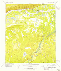
1954 Map of Kantishna River D-2
USGS Topo · Published 1956About this map
Manley Hot Springs serves as the focal point of this interior Alaska survey, where the Tanana River and Hot Springs Slough define the northern lowlands. The map reveals a remote landscape of subsistence and transportation, marked by several Cabins and the Hot Springs Landing. North of the river, the rising elevation of Bean Ridge is dissected by Rock Creek and McCloud Bench Creek, while to the south, the heavily meandered Zitziana River winds through a vast marshy plain toward Bear Lake.
Find a feature on this map
14 named features on this map. Tap any name to fly to it.
Don’t see what you’re looking for? This feature index may not catch every label — zoom into the map to look around manually.
Map Details
Editions of this 1954 Kantishna River D-2 Map
This is the sole edition of this map. No revisions or reprints were ever made.
Other maps of this area

1948 · Kantishna River
USGS Topo · 1:250,000

1951 · Kantishna River
USGS Topo · 1:250,000

1951 · Tanana
USGS Topo · 1:250,000

1952 · Tanana A-1
USGS Topo · 1:63,360

1952 · Tanana A-3
USGS Topo · 1:63,360

1952 · Kantishna River C-1
USGS Topo · 1:63,360

1952 · Tanana A-2
USGS Topo · 1:63,360

1952 · Kantishna River
USGS Topo · 1:250,000

1952 · Kantishna River D-2
USGS Topo · 1:63,360

1952 · Kantishna River D-3
USGS Topo · 1:63,360